
Geologic Road Trip–Boulder Flatirons
Boulder Flatirons, Colorado (Excerpted from 101 American Geo-Sites You've Gotta See by Albert B. Dickas)
“Turn! Turn! Turn!” the often-quoted song presented by the rock group The Byrds in 1965, based on verses from the book of Ecclesiastes, includes the phrase “a time to build up, a time to break down.” In Colorado, another “rock narration,” centered upon the five ramparts that identify the Front Range of the Rocky Mountains outside Boulder, offers dramatic evidence of just such a time occurring during a long span of geologic history.
A time to build up: For 3,000 million years Earth experienced its rites of passage of birth, adolescence, and middle age. A brittle crust enveloped a near-molten mantle, surrounding a molten core. Volcanoes belched forth lava and ash, and earthquakes transformed the early topography. Once the early poisonous atmosphere was neutralized, life responded positively. Critters crawled from the oceans, scampered about the protocontinents, and assumed amphibian habits through evolution. Proto–North America slowly collided with proto–South America and Africa, resulting in a tectonic fender bender—the uplifting of the ancestral Rockies—that stretched from Wyoming to New Mexico.
A time to break down: Rivers transported floods of debris off the ancestral Rockies. The first deposit, the Fountain Formation, lay directly on the Precambrian basement. The deposition of three more formations followed: the Lyons, representing desert conditions marked by sand dunes; and the Lykins and Morrison, both floodplain deposits. As the Morrison Formation was deposited, both herbivores and carnivores sallied across the marshy lowlands in search of mates and food. Preserved footprints and fossilized bones of more than seventy species attest to this being the Age of Dinosaurs.
Change was under way. Throughout the Cretaceous period, waters of the Western Interior Seaway advanced and retreated, altering the environment from terrestrial to marine and resulting in three more sequences of strata, together measuring 10,000 feet thick. The Benton and Pierre formations, mostly shale deposited in offshore conditions and sands deposited in nearshore waters, are separated by the Niobrara, a limestone deposited in deep water. Around 65 million years ago generous volumes of magma invaded and uplifted the Precambrian basement, along with the overlying, younger sedimentary rock, which was bent into complex folds that extended for hundreds of miles. Gold, silver, lead, and tungsten precipitated from the hot waters of the magma and formed the world-class Colorado Mineral Belt. Dinosaurs died out and mammals dominated, setting the stage for the evolution of humankind. The modern Rockies were born.
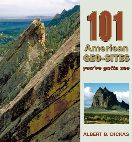
Over time, erosion partially removed the blanket of younger strata from the cap of the Rockies, leaving the Precambrian granite core flanked by the remains of the sedimentary cover. A juxtaposition of topographic high and low identified the Front Range, the geographic contact of prairie and mountain. Finally, river torrents created adjoining canyons in Boulder (and other areas along the Front Range), sculpting the massive layer of red-hued Fountain Formation into triangle-shaped ramparts. The 50-degree angle of the resulting five Flatirons is ample and overwhelming evidence of the prodigious power of continental-scale mountain building, considering that the Fountain Formation had been deposited in horizontal layers. The soaring, imposing, and stark slablike appearance of the Flatirons is nature’s way of emphasizing this dramatic story of long-term geologic development. The Boulder Flatirons are the true rock-stars of time and geologic processes.

#12-FIGURE 1
CAPTION: The Boulder Flatirons form the east flank of Green Mountain. —Courtesy of John Karachewski, www.geoscapesphotography.com